


La Brigue Saorge

taguette
User
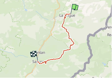

Length
21 km

Max alt
1558 m

Uphill gradient
1035 m
Km-Effort
36 km

Min alt
505 m

Downhill gradient
1304 m
Boucle
No
Creation date :
2023-09-13 06:00:10.874
Updated on :
2023-09-13 12:31:59.67
6h26
Difficulty : Difficult

FREE GPS app for hiking
 SityTrail
IGN / Geographical institutes
SityTrail Plus
The world is yours!
About
Trail Walking of 21 km to be discovered at Provence-Alpes-Côte d'Azur, Maritime Alps, La Brigue. This trail is proposed by taguette.
Positioning
Country:
France
Region :
Provence-Alpes-Côte d'Azur
Department/Province :
Maritime Alps
Municipality :
La Brigue
Location:
Unknown
Start:(Dec)
Start:(UTM)
389752 ; 4879872 (32T) N.
Comments